Postscript: I don’t think any of the cyclists bound for Alaska told me how they were getting there from where we met. There’s some good information on that question in Bob Broughton’s FAQ. I like his first answer best.
Q: How long will it take to bicycle up the coast from Vancouver to Alaska?
A: It depends on how long it takes to build the road. 🙂
(The cyclist who planned to go to Terra del Fuego came down from Alaska on the Cassiar Highway, which I hoped to ride someday too.)
I landed in Anacortes around 3:00 pm. It was only 18 miles to Bayview State Park from there. I followed an Adventure Cycling map, which makes it easy to find backroads. The park was well kept, and there was a grassy picnic area right on Puget Sound.
They even provide firewood, but I only needed a ounce or so of stove fuel. I was now looking west across the sound instead of east. Tomorrow I’ll ride along the Skagit River into the North Cascades.
I got up early in the morning for the long ride to North Cascades National Park. I stopped for a second breakfast when I got to Sedro-Woolley. I walked right in and sat at the counter. I soon realized that I had picked a one-star cafe, complete with denizens of the night.
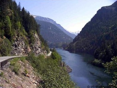
They were very curious, and the food was very good. Then I rode over the Skagit River to take a backroad instead of going up Highway 20. It was a long, lonely stretch, with virtually no traffic. I did need to stop under big trees from time to time to keep out of rain showers.
That road ended near a small town called Concrete (probably where they made concrete for the dams ahead). I crossed over the Skagit again, and was on Highway 20. The road was still relatively flat up to the National Park.
The campground was small for a National Park, but many times the size of all the other camps I had stopped at. I particularly enjoyed the huge trees there. From here on it’s all uphill until I make it over Washington Pass at 5,477 feet. Then it’s down 1,000 feet, and back up to 4,875 feet at Rainy pass.
 The climb over Washington and Rainy passes was challenging. I was trying to stay ahead of the rain, which chased me all the way to the top. It took six hours. I did get a few sprinkles, but stayed dry.
Of course it was dry on the other side, and I coasted down it for 10 miles at about 25 mph. I planned to camp in Wintrop, which was 20 easy miles further on. When I got there I discovered it was completely occupied by a motorcycle rally. They invited me to squeeze in, but it was only a few miles to Twisp, so I continued on.
There is a KOA campground in Twisp on the Methow River. It was surprisingly well kept. I met three or four guys there who were riding from Sedro-Woolley to Lake Chelan. They were not carrying much gear.
They left a while after I did in the morning, and passed me on the way to Pateros, on the Columbia River. A little while later I passed them. They were taking a break even though it was slightly downhill all the way.
This pattern continued until we parted at the Columbia River. They were surprised that even though I was on a loaded bike, I was keeping up with them. Each time we met they had more questions. They wanted to know how far I had gone, how old I was, etc. One of the fellows always responded, “Awesome,” each time I answered.
I’m sure they got to Chelan. I’ve ridden that stretch of the river up and back many times, including the climb up to Chelan. They only had to go one way.
I went on to the campground at Bridgeport. It’s between town and the south bank of the Columbia River, which was flowing strongly — much like the Skeena River when I saw it.
Tomorrow I have another challenge. I’ll drop down to Grand Coulee, and then I face a long climb back up from the Columbia River to Wartertown Plateau. I’m dead certain it won’t be raining though. And I don’t need “no stinkin’ maps” to get home from here.

awesome!
LikeLike
You liked that huh?
LikeLike