“Top of the World Highway” — what an enticing boast. This was the big ride I’d been eager to attack. The name has an magnetic attraction like “Going to the Sun Highway” does. (That’s a supposedly formidable road over the mountains at Glacier National Park. I’ve ridden over that one both ways. It’s tricky in a car, but not hard on the right bicycle.)
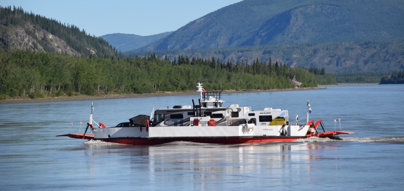 The little George Black ferry took me across the Yukon River to the start of what was then a gravel road to Alaska. I was hoping the relatively dry summer had left Top of the World in good condition but Bob Broughton’s description was still in the back of in mind.
“It is unpaved, often soft, and when wet becomes impassable. It is also very hilly. Bad road!”
Here’s how the ride went: It was a killer, only because I did it in one day. The road was good, but there are a never ending series of hills to climb. I was glad to find the first three miles, which I’d heard were covered with 2″ gravel, now covered with soil and smaller gravel. The first hill was the biggest one. It took me two hours to climb from the ferry up to the “top of the world.” There was also a long, steep hill just before the border. It ruined my vision of just cruising to the crossing.
You can see for maybe 100 miles in all directions from various spots up on top. The terrain is big, rounded hills covered with tundra. They fall away toward the Yukon River to the north and east, and there are big mountains to the south and west. You got a first-hand feel up there for how big Yukon and Alaska are.
I was carrying more than a gallon of water and food for four days, so my load wasn’t light. It was 70 miles to the border, and I hoped to go a bit beyond that. Turned out I wouldn’t have needed all that water. I found a spring by the side of the road at just the right spot, but I never regret not needing to use my insurance.
The advisory signs for the Alaska border crossing at the start of the ride were confusing. There was no clue if the border closed on Alaska or Yukon time, or whether it was Daylight Saving Time or not. I guessed it was Alaska time and rode hard all day but ended up getting there half an hour too late. [border photos]

I didn’t want to camp right there at the border, so I went back up the road aways. I learned something new about tundra when I went to set up my tent. There are clouds of mosquitos in it.
I’d eaten right on the side of the road, but I wanted to get off on the tundra for the night. I ended up not even using the poles for my tent. You can’t do that and swat mosquitoes at the same time. I crawled into my tent and zipped the mosquito netting behind me as quick as I could.
I went back to the road for breakfast in the morning. The mosquitoes were too cold to fly, but I needed a flat spot for cooking (tundra is thick, soft and lumpy). There were a dozen motorhomes waiting to cross the border, and I got in line behind them after loading my bike again. When it was 8:00 am, the agent came back to where I was and told me to go to the front of the line. Great.
Jeff, the agent, looked at my passport and asked some customs questions. He wanted to know if I liked gourmet coffee. I wondered if that was a trick question, but I said yes. He invited me to wait on the porch of the customs building, and told me he would brew some when he finished with the traffic. “That way the dust from the motorhomes will settle before you start off,” he said. (It also meant they wouldn’t all be passing me one at a time.)
I went up on the porch and waited for Jeff to finish. The building was built with real notched logs. The coffee was very good. I didn’t think to ask him if he had roasted the beans that morning, though. We talked quite a while about how great it was to be up there. He and his wife were only there a few months a year, because the road closes in the fall.
Jeff had several stories about other cyclists, and one about a fellow who rode there from South America on a horse. Actually it took four horses and six years for him to get there. Then he took my picture (using my camera and ill-fated film). I stood in front of a sigh that said “Most Northerly Border Crossing into the US.”
I had a feeling Jeff followed a similar routine on many mornings. I said thanks and goodbye, and was off down the road to lower terrain. The name changes to Tailor Highway in Alaska, but some people consider it to be part of the Top of the World Highway.

I’ve always enjoyed the story of Jeff and the coffee!
Ugh, mosquitos. I certainly remember my waiting along the Tuolumne River under mosquito netting while everyone looked for quick Cathy 😉
LikeLike
I didn’t remember the mosquitos there. Probably because I was moving around so fast looking for Cathy. Fortunately, the mosquitoes weren’t bad anyplace else. And no black flies like there were in BC the year before.
LikeLike