4. AK, BC & YT — Dawson City

I had eight rolls of film that fell into a black hole somewhere between Alaska and Seattle that documented this tour. They’re gone, but I struck my own gold while-while writing this post. Internet gold that is — stumbled across Sue Thomas’s ideally suited website.

Sue and her husband have toured Yukon and Alaska extensively in a mobile home. Her website has excellent photos of many of the same routes and places I’m writing about. I’ll be weaving them into my narratives, and integrating them with some previous posts too. I’ll do that by adding a [photo] link at spots where there’s a relevant photo. Click those links and use her list of contents, or scroll/swipe, to find the pertinent photos.

*******

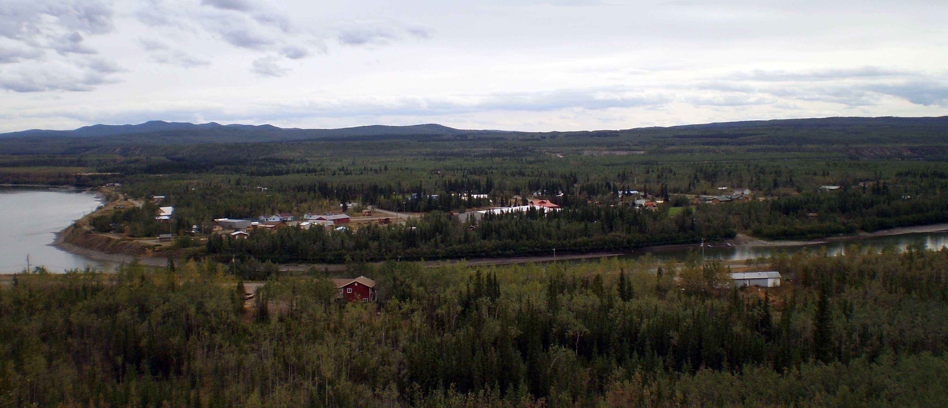
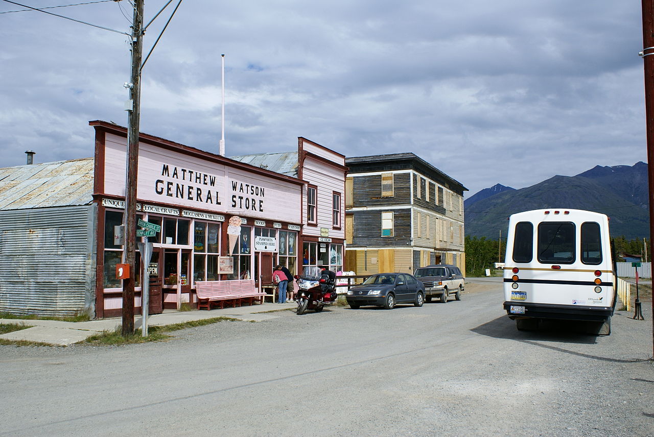
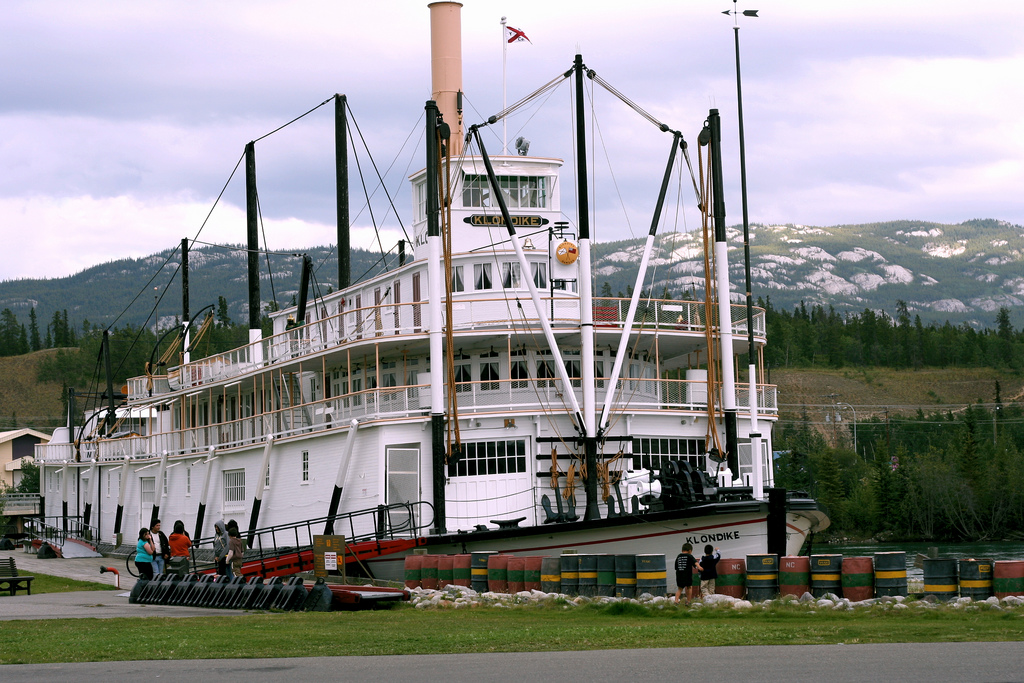
Dawson City is merely a shadow of what it was during the short heyday of the Klondike gold rush — 1,375 people vs. 40,000. The compact commercial district is the primary remnant from those days — some of it old, some of it new, and much of it derelict. Echoes of the Klondike, prospectors and miners, George Pantages, Jack London, Call of the Wild, sternwheelers, Robert Service, et al., are still almost audible in Dawson City. [photos]

The map below shows the devastation that gold dredge operations left behind at Klondike Creek. Zoom in on the map and center it to see more detail. Those worm-like objects are huge gravel piles left behind by gold dredging. The topsoil is buried 20 feet under the gravel. Sad.


I went on a tour organized by the RV park the next day after arriving there. We went up Bonanza Creek and saw some small scale placer mining operations first. Next, we went to see Dredge #4, which is the largest one ever built in North America — placer mining on steroids.

The dredge is a barge equipped for continuous placer mining. It has a big chain of buckets in front — much like a ditch digger — to feed the soil and gravel into the processor. The processor is a series of screens and sluice boxes that separated the gold from the waste. The waste was distributed in a continuous pile by a conveyor belt at the back of the barge. The whole thing floated along in its own pond, chewing up the landscape and spitting out the gold. [photos]

We went to downtown Dawson City after visiting the gold field. It was interesting to see what permafrost does to buildings there. I came away from the tour with a good idea of what to explore the next day. After the tour I made some changes to my bike to get it ready for the ride to Chicken, AK. Then I went back downtown to get groceries and a canister of bear spray for the ride. More about that later…

I spent all day downtown the next day. I started off at the Robert Service and Jack London cabins. They are next to each other There were informative and entertaining curators at both of them. I took a bunch of pictures around town, including those cabins, but you already know the sad outcome of that enterprise. [photos]

Robert Service was the original Rolling Stone. I mentioned before that he is the Canadian counterpart of Robert Burns — often referred to as “Bard of the Yukon.” He had a cabin in Dawson City after the gold rush where he wrote his novel The Trail of Ninety-Eight and his poetry collection Rhymes of a Rolling Stone.

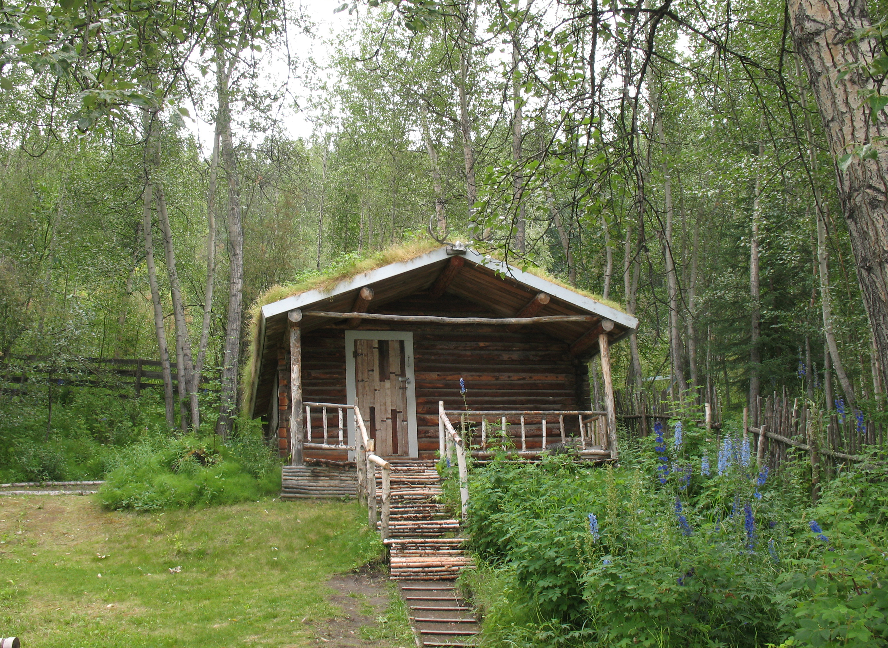
His cabin is a preserved historic attraction in Dawson City. Entertainers recite his poetry and tell other tales of the Yukon there. One of my companions on a tour to Jasper recited Cremation of Sam McGhee, so I knew who Robert Service was. It was nice to hear more about him and more of his poetry at the place where he wrote it.

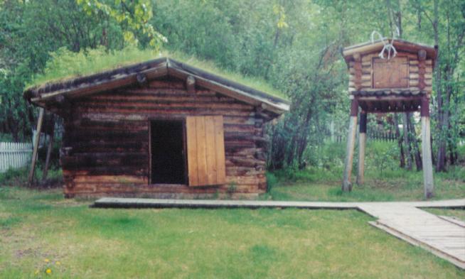
Jack London came to the Klondike in 1887. He rented a tiny cabin there from two mining enginers, one from Stanford and the other from Yale. The cabin was discovered in the woods many years later. Half the logs (plus new ones) were used to rebuild one in Dawson City and another in Jack London Square in Oakland, CA. The little building on stilts is a bear-proof storage shed.

I read half a dozen of Jack London’s books in grade school. They were engrossing to say the least. Today they seem a little juvenile. I imagine they made me long for that kind of adventure though.

Like many people in the Klondike, London came close to dying of scurvy. There was little to no fresh food there in the winter, so they weren’t getting Vitamin C. Nobody knew rose hips contain a lot of it. Many wild roses grow there, and some rose-hip tea would have fixed them right up. Or they could have just ordered sidecars at the bar. 😀

Many old buildings in Dawson City show the whimsical effects that permafrost produces. Other than that they are well preserved in that climate. Permafrost causes the soil to heave and subside with the seasons. The only way to maintain a building in this envionment is to level the foundation each summer. And most empty buildings don’t have anyone with enough interest to get out the jacks. [photos]

I had dinner at the Triple Jay Hotel. My notes say I had Tortellini but didn’t know why. It was a puzzle because pasta was one of the main staples on the tour, but evidently the meal was quite good. Then I went to the Palace Grand Theatre to see the Klondike Follies. An elegant dinner-theatre date with myself. [photos]

The follies were a lot of fun. The theater had been replicated board-by-board in exact detail from the ground up. Permafrost had ruined the original. I bought a box seat, which gave me a splendid view. It even had a stove pipe in the corner that came up through the floor from a wood stove and exited through the roof. [photos] [PBS webpage/video: Palace Grand Theatre]

A black fellow wrote and directed the Klondike Follies for their Gold Rush Centennial. He was also one of the main characters and did some first-class tap dancing too. It was all about nuggets, Mounties, miners, dance hall girls, etc. Very provincial. The place was packed, and there were laughs aplenty.

I rode back to my tent sometime after 10 pm. Of course, there was still plenty of light to ride by. The next day was going to be a big ride. I hoped to get over the border and camp in Alaska. I was anxious to see what the big, bad road held in store.

[PBS video: The Klondike Gold Rush]

3.b AK, BC & YT — Klondike Highway

Pelly Crossing was my next stop after Carmacks. It’s another First Nations town —  about 300 people. I camped right by the Pelly River. It is about the same size as the Yukon was at Carmacks. They join at Fort Campbell. Robert Thompson, son of the legendary explorer David Thompson, established Fort Campbell as a trading post.

The ride here was tough. There were three big climbs. The road on one of them was under construction. I passed through a big — 500 square miles — burn on the way. This is dry country. The fire was probably started by lightning.

The town sits in a pretty spot. There were many big Ravens in Pelly Crossing. I don’t know what attracts them. My notes say the people were friendly, but that’s not surprising up here. I camped on my own little knoll right by the river.

I enjoyed the sound of rain on a tin roof the next night at Moose Creek Lodge. I had stopped to eat there and soon the rain started. The lodge offered hot showers, and I thought that would be nice. But getting a room seemed nicer when the rain started. It had gotten cold and there was no telling when the rain would stop.

The hot showers were separate, and the “room” was a tiny log cabin with a tin roof. It also had a front porch where I could put my bike out of the rain. It was heated by a propane stove, which made it much cozier than a tent. Listening to the rain on the roof put me to sleep. What luxury.

It stopped raining by morning, but it was a gray day. I got going after breakfast in the lodge. I hoped it wouldn’t rain. It was 100 miles to Dawson City so I decided to take two days to do it.

I met a young couple from France coming toward me. They had started in Anchorage, ridden through much of Alaska, and were returning from Fort McPherson. That was 600-mile side trip (total) beyond the Artic Circle on the Dempster Highway. They were now on their way to South America.

I thought about going up there too, on and off, for the rest of the day. The fact that it was a gravel road helped me decide not to go. That saved me a couple of weeks, but now I wish I had gone.

I had planned to go 50 miles the first day after leaving Pelly Crossing, but I found no inviting campsites at that point. I went on to an overlook at 60 miles. Nothing there either It was downhill from there so I continued on. I ended up at the Klondike Lodge at the intersection with the Dempster Highway. I was now 500 miles from Skagway. No, I still wasn’t going to Fort McPherson.

I had camped across the highway from the lodge. A hitchhiker who was waiting for a ride to Fort McPherson joined me. It was 11:30 pm by then and the sun was still up. I didn’t wait for it to set, I went to bed. One nice thing about cycling: You don’t have any trouble sleeping.

I arrived at the Guggie Ville campground, a couple of miles outside Dawson City, early the next day. It sits on top of tailings from the gold dredging operations on Bonanza Creek. I went to Dawson City in the afternoon. I looked around, and I would be back the next day.

Panning for gold is one of the attractions at Guggie Ville. The have two troughs of sand and water that they salt with gold flakes. I had some fun learning to pan, but I no longer know what happened to the flakes I found.

The couple who owned the place spent 20 years scrounging for gold and decided to quit and build Guggie Ville. (Maybe their name is Googie?) On the last day they looked for gold, they found a 20 oz. nugget. The woman I talked with said not going back was the hardest thing they ever did.

[pictures]

3.a AK, BC & YT — Klondike Highway

The next leg of my ride started with a climb up out of the Yukon River valley. Klondike Highway separates from Alaska Highway up there, and then it’s 330 miles to Dawson City. Three days on a road bike accompanied by a support van — a few more on a loaded mountain bike. 😀

The terrain is small, rolling granite hills, mixed with many lakes and patches of gravel. The Cordilleran Ice Sheet left that all behind only 12,000 years ago. The country here is sparsely populated (fewer than 10,00 people live outside of Whitehorse), which adds to its charm.

I’ve written before about the social magic a bicycle tourist enjoys on the road. I arrived at Braeburn Lodge, my first stop on the ride to Dawson City, in the middle of the afternoon. Some trucks that passed me a few miles back were parked there. I went in, and there were the truckers eating $5 cinnamon buns. (There’s a Cinnamon Bun Airstrip across the road, and they stage a 200-mile Cinnamon Bun dog sled race in the winter.)

They though I was making good time and wondered if I was going far. I said, ‘Yeah, is this the way to the North Pole?’ They responded with some misdirection. Then I told them where I was going. They wanted to know if had a tire pump (I had two) and if I’d had any flats (none). We engaged in more banter while I waited for my hamburger.

The “lodge” looked like it was a roadhouse back in the day. There was an old piano with candlesticks mounted on either side of the music rack, and the room was big enough for a dance floor at one end.

The hamburger arrived on a homemade bun about 9″ in diameter and 3″ thick. I had to cut it up like a pizza to eat it. It was the biggest hamburger I’ve ever eaten by far. Good though.

I asked the waitress where people camped around here, and she said I could camp by a (dry) creek a quarter of a mile back. There was even an outhouse there. She told me, “We have a family of bears that lives around here. Don’t worry, you’ll hear the dogs barking if they come around.” Very comforting.

There was a prairie dog town there too. Two of the young ones were having a wrestling match. I hung my food in a tree, set up my tent, wrote in my journal, and studied my map.

Robert, a cyclist from Germany, joined me. He had ridden to Jasper, AB from Vancouver, BC and up the Alaska Highway to here. He was about 20 years old and was hauling an amazing amount of gear. For example, a big camera with four lenses. Oh to be 18 again.

The Yukon leg of my tour. It shows where Carmacks fits in. Looks as if most of Top-of-the-World Highway is now paved. Click to embiggen.

The next morning I got up before Robert and headed for Carmacks. He must have started a half hour after I did because he caught up with me at lunch time. I rode with him for a while, but I couldn’t keep up for long. The map shows where Carmacks fits in the ride.

Later, I met a cyclist from Valdez, AK coming the other way. He advised me not to ride from Fairbanks to Anchorage because it is mobbed with RV’s and motorhomes. No problem. I was planning to take the train anyway. He also said the first three miles of Top-of-the-World Highway out of Dawson City were bad. They only had a base layer of 2″ gravel and they were steep. Oh well, I could walk the bike. (It turned out to be fine when I got there.)

It was an easy ride to Carmacks — downhill with a tailwind. It’s a pretty town of about 500 — mostly First Nations people. I could have easily gone on but I’d have ended up in the middle of nowhere. Here in the park/campground, I had a table, water and a good place to hoist my food to defeat any bears. The general store was well stocked, and I now have enough food to get to Dawson.

There was a guy sleeping on a table in the group shelter (just a roof and tables) when I got to the park. I figured he was drunk. Might have been. Turns out he was blind, and someone had dumped him off here. A fellow from North Dakota helped him get across the bridge because he wanted to get to the other side of the Yukon River.

Now that the drama was over, I could go use one of the tables and I’d be able to hoist my food up to a beam. I fixed some hot chocolate and a couple in a motorhome brought me a hot homemade bun to go with it. They had baked it over an open fire.

All the while I had been riding along beside the Yukon River there was a Klondike Centennial Canoe Race (1897/1997) going down the river. I watched one of the big canoes come in at the Carmacks checkpoint. The crews were required to rest for three hours here before going on. This team got passed by most of the other canoes during the night because they got too sleepy and had to stop.

I had a hamburger and a sundae at “Penny’s Place”, which was not much more than an open-air stand. They were good, but the hamburger was just a quarter-pounder. I talked with a Russian there who worked in Washington, DC. He went to Alaska the year before and liked it so much he came to the Yukon. He took a picture of me with my bike to remember our conversation.

[pictures]

2. AK, BC & YT — Whitehorse

The sun comes up early here in June, and I was up early too. The Klondike Highway is a paved road here but the traffic is light. I don’t think any vehicles went by during the night. Good thing, I was only 60 feet off the road.

It was about 80 miles to Whitehorse from my roadside camp, but that would be a long day on a mountain bike. I decided to camp in Carcross (short for Cariboo Crossing) instead. That was only about 30 miles away and would give me time to get things dried and sorted out. (It rained for most of the rest of the voyage from Ketchikan to Skagway, and some things were still soaked.)

Now it was time for breakfast. But no! I left the fuel for my stove on the ferry. They require you to store it in the paint locker during the voyage. In my haste to start riding, I forgot it. Well, no morning coffee or oatmeal. I ate granola with water instead.

Downtown Carcross — looks as if the hotel has closed since I was there.

Carcross is a nice little town of about 300 First Nations people. It is on the migration path of a herd of Cariboo. I found a place to camp there for $5. I went downtown to the Cariboo Hotel after I got my wet gear hung up on a line. There I had the worst fish and chips I’ve ever eaten. I should have eaten my can of beans cold instead.

I also called Marcia in Minnesota from the hotel. She and Jane have a nice cabin in Crosby, but it is hot and muggy there. There were no cell phones in the country I was in, but I had a Sprint calling card that let you make inexpensive calls from pay phones. You dialed a Sprint number, and then dialed the number you wanted. I called every few days after that.

It was an easy ride to Whitehorse on the Yukon River the next day. That was the route to the Klondike because the prospectors could float all the way to Dawson City. The Klondike Highway parallels the river most of the way. As I said before, that makes it all — including Whitehorse — (slightly) downhill from here. Sweet words for a cyclist.

I had a great hamburger steak where the Klondike Highway joins the Alaska (formerly Alkan) Highway. It is a busy road with lots of trucks and buses as well as cars. I was in another world. It was only a few miles further on to Whitehorse, and I was soon lodged in Robert Service Campground. (Robert Service is the Canadian counterpart of Robert Burns, Scotland’s venerated poet.)

I bought a copy of Milepost, “The Bible of North Country Travel,” when I was planning this trip. That’s where I found places like Robert Service Campground. It’s a big, thick book, so I disassembled it and took just the pages I needed with me. Here is the map of my outbound journey:

I had the usual bar ends (hand grips) on my mountain bike handlebar. They’re great for climbing a steep hill in the woods, but I found they are too far apart for riding all day. So I tried a radical change. I moved the bar ends inside of the brake and shift levers, which meant those had to come off before I could move the bar ends (now bar middles I guess). It took an hour or two to swap everything, and I hoped it worked out.

The cyclist camped next to me came over and told me she had some problems on her bike. I guess she could see I knew how to work on them. I learned she was from France and was going to ride on up the Alaska Highway in a few days. (I would peel off on the Klondike Highway, headed for Dawson City.) I had the right spare parts to fix her bike and she was very happy. (We’ll learn more about her later.)

Then I went downtown to get fuel, a cord for my bear rig, and groceries. There were many more bicycles in downtown Whitehorse than I could have imagined. Most of them were riding confidently in traffic like they are supposed to. Amazing. Whitehorse is a commerce hub like Spokane, but it serves an area 800 miles in diameter instead of 200. It was bustling.

On the advice of a camp caretaker, I tried some “Quebec True Poutine” for lunch the next day. It’s a big bowl of French fries covered with “lump” cheese (like cottage cheese) and smothered with gravy. Probably 2,500 calories. I later figured I ate 5,000 calories a day on the ride (and lost 20 pounds by the end) so that was about right for lunch.

I went to see the big old SS Klondike sternwheeler too. It’s a National Monument in Whitehorse. It is handsome. Mark Twain would have surely loved it. There was no road to Dawson City until about 1950. Sternwheelers served as the primary transportation.  [Photos of Whitehorse]

I spent the rest of the day watching the Yukon flow and getting things organized for the next day. I separated all the food and other odiferous items from my clothing and other supplies. That reduced the weight of items bears would like. My “patented” bear rig was an combination of some sailing tackle and two stout lines. I used it to hoist my food up to an overhanging tree limb, shelter beam or anything that would put it out of reach.

I don’t remember seeing any bears on the trip except grizzlys in Denali National Park, though. Mother moose kill more people up north here than bears anyway, and I saw plenty of them. But they don’t eat people food. 😉

There isn’t much from here on until Dawson City. Just a couple of places to eat, a couple of sketchy general stores, a few campgrounds and that’s it. I had the bike fully loaded, and was pretty sure I would make the 330 miles without going hungry.

[pictures]

*******

I have revised the previous post a bit for accuracy…