Solo Backpack — Part Three

In the previous post, I wrote about water rising around me in the night. After breakfast the next day, I waded off my little island barefoot.  Then I continued up the valley after putting my boots back on. The Merced dwindles to a large creek at this point and at first, the slope going up was still moderate.

I was soon lulled into a phantasy of cruising along without much effort. But the trail veered away to climb up to a higher bench on the mountain. I was soon convinced it was time for a snack.

I propped my pack against a big rock and chose a few items. I had enjoyed dry salami for breakfast, so I sliced some of that too. It was hard to choke down as a snack. Oh well. I would just have to live with my mistake (related in Part One) for the rest of the hike. A couple of Marcia’s killer chocolate chip cookies helped kill the taste, though.

The pass I needed to reach is a little to the northwest of Mt. Clark.
The pass I needed to reach is a little to the northwest of Mt. Clark. Click the image to see the identifier.

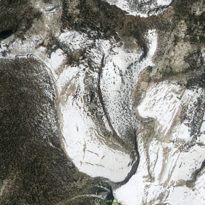
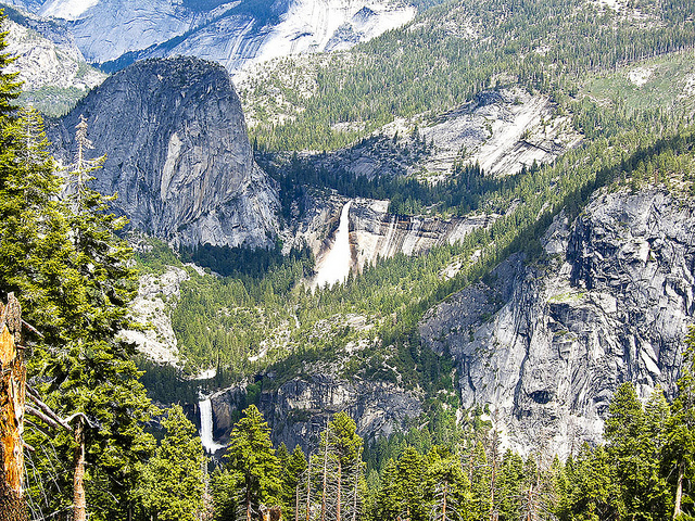
After two or three hours of hiking, I could see the big bowl that I would need to climb out of.  The next campground was on the other side or the brim. To my dismay, the bowl was covered with snow all the way up.  I should have known it would be, this early in the season. The bowl is north-facing and gets little or no sun. Lesson three… That’s one a day so far. 🙂

When I got to the foot of the snowfield I took off my pack and tried going up it. The snow was soft, and of course, I had no snowshoes. My boots sunk in a foot or more as I went along. It would be hard to climb to the brim, even if I had a whole day and no pack to carry. I was also concerned about triggering an avalanche. I didn’t know much them then, but now I know there was no danger. (I did make it up to Mt. Clark and down over that brim a few years later.)

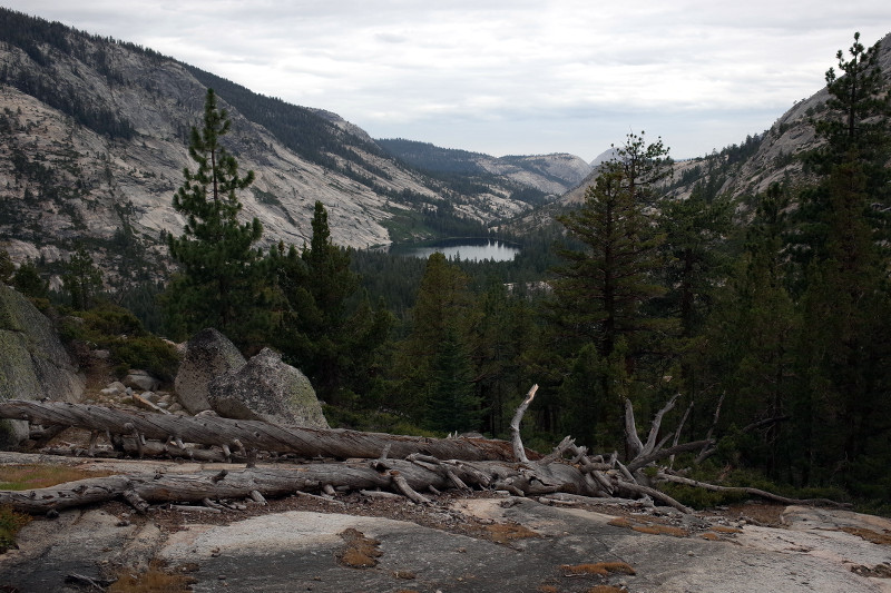
There was plenty of time left in the day to go further so I got out my big Yosemite map. There was a good view to the north, but it didn’t look interesting out there and there were no campgrounds. There was a campground to the west that I would have time to reach, but it was over a pass that was probably snowed in too.

tubeI decided to break the camping rules again and camp right where I was. (A few years later the Park Service realized camping at random would be less harmful.) After setting up my tent, I realized there was a dead tree leaning over the spot I picked. I don’t know how I missed that. I just had a tube tent, so it was easy to move.

After studying the map some more, I decided to backtrack and then go east the next day. It looked as if there was a nice hike down Lafferty Creek to Tuolumne Meadows. Then it would be a long hike down a long, south-facing slope back to Nevada Falls. And there were well-placed campgrounds along the way.

I started back down the trail in the morning. It was a letdown, but the scenery was entirely different going the other way. And thinking about the adventure of my new loop soon changed my outlook. I was eager to see what was over the mountain

Solo Backpack — Part Two

Even in the 1960s, Yosemite Valley was congested in the summer. I decided to start my big trip in late May to beat the vacation season. That way I’d find a parking spot when I got there. It turned out that put a kink in my careful plan (read on).

Many hikers take a GPS [Global Positioning System] into the wilderness. That would take the edge off the adventure, it seems to me. Using a detailed map may also seem like cheating, but even Louis and Clark used a map on the Voyage of Discovery. It was drawn by David Thompson — perhaps the greatest geographer of all time.

The USGS provides beautifully detailed topographical maps of various scales, including a special one for Yosemite. Camping in National Parks was only allowed in designated campsites in those days. (I do give them credit: They eventually realized the negative effects of that regulation and revised it.)

I used that big USGS map to plan my stops. Being a confirmed map lover, I carried it with me on the trip too. I never thought of it as cheating. It just seemed prudent.

I got to Yosemite Valley in the afternoon. My first stop was the ranger station to get a backcountry permit. The ranger asked how many were in our party. When I told him “one,” I saw disapproval on his face. After a few moments, I saw he resigned himself to the fact that he was required to issue this fool a permit anyway.

I planned to cheat on the rules for the first night. There was no way I could make it to the top of Vernal and Nevada falls, and then hike more than five miles to the first designated campsite at Merced Lake. I would just go off the trail into the woods and lay out my sleeping bag.

vernal-nevadaThe hike up Mist Trail to the top of the falls just about wore me out. It’s more than a 1,500-foot climb from the valley floor. I learned it was much harder than without a pack. Then I went on up the trail a couple of miles and off into the trees. I was in my sleeping bag by the time it was dark.

I woke in the middle of the night and found that a bear was dragging me and my sleeping bag further into the woods. Of course, I was alarmed, but he soon dropped me. But where was I? And how could I find my way back in the dark?

When I got out of my sleeping bag, I found that somehow my other gear was right there with me. How could that be? Then it dawned on me that it was all a dream. It was so real that I had not sensed any transition from dreaming to being awake. It was a hallucination, brought on by exhaustion. I was more amused than frightened by then.

I’ve been up close to several real bears since then, but never felt unduly alarmed. I was concerned when some campground bears visited our camp one night, though. They evidently lived on garbage at that over-used campsite. I built a fire after the third one came nosing around.

merced-lakeI had an easy hike to Merced Lake the next day. One of the delights was drinking from the many little streams that feed the Merced River along that stretch. Since it was May, they were filled with snowmelt. I dipped my cup in each one and enjoyed the ice-cold water.

Merced Lake Campground is heavily overused. I bent the rules a bit there. I found a flat spot on the fringe of the campground where the river enters the lake and set up my modest camp. Then I went fishing. I used my small spinning rod and reel to try a variety of lures. I soon found one the fish liked, and took three nice ones for dinner.

I had a surprise in the morning. The river, which is not much more than a large creek here at the lake, had risen about six inches. There I was on a little hump with water all around me. The bulk of the snowmelt arrives at night after it is melted by the sun during the day. I didn’t know that when I set up camp. Oh well, I just waded through the ice water and sat on a rock to put my boots on. Then I was on my way upstream.

Solo Backpack — Part One

foxI recently re-read Ernest Hemingway’s Big Two-Hearted River. It is my favorite short story. I first read it years ago. I liked it because it succinctly detailed many things I had experienced myself. The style of camping he describes is much like what I knew as a boy — effective but primitive. It was more woods-craft-like than the refined equipment and methods of today.

Reading the story now was a chance encounter. I knew much more this time about the context of what Hemingway was writing. Big Two-Hearted River reflects his WW I experiences and observations. He wrote it using the trademark style he was developing at the time. I was glad I had forgotten most of the details of the story. It was a delight to read it again.

On to backpacking: I took a break from posting to Didit.live for a while. I was hoping to find our backpacking journals after we arrived in Surprise. They don’t seem to be here either, so I’m starting a series of posts without them.

prince-albertWhile there wasn’t any outright camping involved at Spar City, many of the basic chores and activities were similar to those in Big Two-Hearted River. The fishing was nearly the same, including catching grasshoppers (we kept ours in Prince Albert tobacco tins, though). Spar City gave me a good background for backpacking.

***************************************************

I realized the possibilities of backpacking on an overnight hike into Desolation Wilderness at Lake Tahoe. It was organized by Art Fong — my good friend and an esteemed engineer at Hewlett-Packard. About a dozen of us went. We had a great time. I particularly enjoyed climbing what I’d call a giant staircase to the top of a peak. I don’t remember many other details, but I did learn quite a bit about gear for backpacking.

Soon after that, I started thinking about more ambitious backpacking. It offered a taste of the life of a mountain man without the hardships. I had been too busy with work and graduate school for much in the way of outdoor activity. I was ready for something new. Backpacking offered adventures that were challenging but not do-or-die . Five days of vacation time plus a weekend on each end would give me nine days to hike.

I could not interest anyone I knew in such a venture.  Why not make it a solo hike? The big question for me would be food, not being alone. Could I carry my camping gear and enough food for nine days?

Food for an ordinary diet is mostly water — 80% or more — and much of it requires refrigeration. The food I packed would need to be dry to cut down weight and avoid spoiling. I wanted a reasonably balanced diet as well. That meant a good mix of carbohydrates, fats and proteins. There was no such thing as freeze-dried food in those days, so I roamed grocery stores looking for ideas.

I made a big mistake on the proteins. I always enjoyed cheese and Italian dry salami appetizers at weekend BBQs. Both would keep well at the cooler temperatures in the mountains. Along with some bacon bars, that would cover the proteins. I figured three rolls of salami would be about right (Wrong! read on…).

Other than the salami, my grub worked out pretty well. I had dry Monterey Jack cheese (superb), pilot biscuits (huge crackers), oatmeal, dried fruit, dried milk, Freetos, peanuts, jerky, figs, dates, M & Ms, Tang, Swiss Miss, and some of Marcia’s killer chocolate-chip cookies.

All of that was good, but I was sick of salami by the third day. It was all I could do to choke it down. I even tried frying it. That tasted good the first time, but worse than cold salami the second time. At least I caught trout for a few dinners.

Keep in mind, the timeframe here is the early 1960s. There was not much available in the way of good equipment for backpacking. Legendary Orchard Supply Mel Cotton’s did have some basics in those days. I got boots, a big pack, a poncho, an aluminum cooking kit, and a sleeping bag there. The poncho would serve as rain gear and lean-to tent.

Backpacking stoves did not yet exist (and I probably didn’t even think of a stove anyway). I found a small wire grid, about 8 by 12 inches, to cook on. I set that over small fires that I built between two rocks. I eventually got a stove, but I cooked with that grid for several years. It worked splendidly for roasting trout.

You need to be extremely careful not to loose things when you’re backpacking. You can’t go to the store to get more matches, replace your knife, find another grill, or replace any other essentials. Those things are all a few days behind you. “A place for everything, and everything in its place,” is the key to success.

***************************************************

The next couple of posts will continue with this first venture into the wilderness. I was lucky that Yosemite was close. It is backpacking heaven, or as John Muir put it, “that gentle wilderness.” Nothing else compares.

Airplane for Sale

I was already thinking about an aerobatic airplane of my own while I was still flying with Steve Wolf. A “one-hole” (single-place) Pitts Special would have been nice, but expensive. I thought about building one myself, but that would take three years. The friends I talked with recommended a Citabria, which is a production (not experimental) aerobatic airplane based on the Aeronca Champ design.

I looked in the usual “Airplanes for Sale” publications (remember, this was before the Internet) but found very few Citabrias, and none of them were located nearby. I was reading Sport Aviation regularly at the time, and a few Citabrias were listed in the ad section. One of them was a low-time (desirable because it hasn’t been flown much) Citabria near Portland. I called the number, and the owner’s mother answered. She said he was on an extensive trip, but would be back in a couple of weeks.

About three weeks later the owner called to find out if I was still interested in the Citabria. He had just returned and found my inquiry on top of the stack where his mother put them. He said he was going to work down the stack, and planned to sell the plane to the first person that arrived with a cashier’s check. I told him I’d meet him at the Portland airport “tomorrow.” Now that’s what I call serendipity.

He told me he was selling the airplane because he lost his medical. He was an airline captain and had blacked out momentarily while flying a 747. Twice. The first time he decided not to report it, although it’s required by FAA regulations. The second time he reported it, but his doctor could not identify the cause. That meant he lost his medical certificate.

My new-used Citabria at a Felts Field hanger.

We drove out to Sunset Air Strip where he had the plane in a hanger. It hadn’t been flown for a few months, so the mechanic did a brief inspection, put a new battery in it, fueled it up, and we went for a test flight. Sure enough, it flew much like an Aeronca Champ. He had already told me the history of the plane — in particular, it had always been hangared. Total engine time was only 700 hours (that’s like 30,000 miles for a car), and he had taken excellent care of the plane. I promised I’d honor his condition to always keep it hangared and gave him my cashier’s check.

Big-Bad-Green fabric patch cut to open an inspection port on the bottom of a wing.

I needed a ferry permit to fly the plane to Henley because it had not had a formal inspection in over a year. We drove to the Hillsboro Airport, where there is a FAA office, to get it. We had lunch at the restaurant while we were there. There we saw some big-bad-green Citabrias parked outside on the ramp. He had never seen another green one before, but there were three of them there.

The weather was not good, and the only way out for me was through the Columbia Gorge. There was a 500 ft. ceiling (bottom of the first cloud layer above the river) there at the time. The short-term forecast for the gorge was not bad, but I could have been in trouble navigating the Portland area if I had to turn back.

The seller insisted on flying the plane to Henley. I knew he wanted to fly it one last time, and since he had flown for United, he could get a flight back for $25. I had a valid license so it would be legal for us to fly. He also had an instrument rating. We could fly in the clouds if the weather deteriorated. Later I learned the flight was not legal after all. Ferry permits do not authorize passengers, and he was technically a passenger. Oh well…

It was raining with poor visibility when we exited the gorge. I started using visual navigation to keep track of where we were. It was my first opportunity to navigate in marginal conditions. The pilot was also using radio navigation as a backup. I won’t go into the technical details, but I learned a great deal on that flight about flying in bad weather.

We eventually lost contact with our exact location, but we had a good handle on where we were generally. We could have used radio navigation to get to Felts Field — and to Henley from there — but he didn’t want to do that yet. I told him we were close enough to Idaho to see the mountains before we went too far east, and it was a straight shot north to Henley from there.

I spotted Lake Coeur d’Alene in a half hour or so. The terrain was instantly familiar to me. That’s the way visual navigation works. If you loose contact with your exact position nothing looks familiar, but if you find a known feature it all snaps into place. We landed at Henley less than an hour later.

I called Marcia to let her know we had arrived. Then we put my plane in a hanger and had $50 hamburgers while we waited. (So called because that’s about what it costs to fly to a nice airport to have one.) Marcia and Barb met us at the restaurant, and we drove my ferry pilot to the Spokane Airport for his flight home.