BC Tour — Route Maps

These two route maps provide an overview of my British Columbia tour. You can zoom the maps in or out, or click & drag them to new locations. If you click “More options” you’ll get a bigger map to see more details

Note: I took a BC ferry to get from Prince Rupert to Port Hardy.

Outbound

Home

BC Tour — Spokane to The Border

Maps are part of these bicycle tour posts. If you don’t see them, I suggest you try a different browser or computing device.

Skeena River from Bob Broughton's "British Columbia/Alaska Cycle Touring" website.
Photograph of Skeena River from Bob Broughton’s “British Columbia/Alaska Cycle Touring” website.

I started planning this tour while riding my Tour of The Rockies the year before. I wanted it to be a self-supported tour in preparation for a more ambitious “retirement tour.” I also wanted to see more of British Columbia, which is a vast open place with lots of mountains, rivers and trees. I also knew the small towns I would go through would be *real* towns like we had in the US fifty years ago.

I was confident that I could handle a solo bicycle tour. Seventy miles a day average on a fully-loaded bicycle – food, water, kitchen, clothes and shelter – was feasible for me. My Tour of The Rockies gave me a good idea of what I would run into. I knew how to maintain and repair bicycles. And life on the road wouldn’t be much different from the solo backpacking trips I’d taken. What could go wrong?

Naturally, I used the Internet to help me plan the tour. I wanted it to be challenging, but not epic. Bob Broughton’s British Columbia/Alaska Cycle Touring website was just right for expanding my concept of the tour. His dark, mysterious picture of the Skeena River led me to settle on Prince Rupert as the destination. A little more research, and I had my route set. I would ride from Spokane to Prince Rupert, and then back via Vancouver Island.

Jake Layte, an engineer I knew at Hewlett-Packard, was an inveterate bicycle tourist. He was originally from Europe. He often returned there for extended tours, and had also toured in Canada. When I told him where I was going, he had some good advice. One thing he told me was, “Bring a spare rear axle.” (He had broken a couple himself while touring.) You’d never think of that, but things happen. Most likely hundreds of miles from a replacement. Jake also told Bob… (forgot his last name), another cyclist at HP, about my tour. Bob wanted to come along, and while I was reluctant, I said OK. More about that later.

This tour started from our front deck. I met Bob down at the Centennial Trail, and we rode to the Trent Ave. bridge. Jake was there to see us off. He wished us luck, gave us both a Powerbar, and off we went. We soon left the trail and took the toughest climb of the tour up to the cliff where Arbor Crest Winery is. From there we took backroads – Spokane Bicycle Club routes – to Loon Lake, just beyond Clayton.

I planned to stop at Colville, which was about 80 miles from home. We could camp in the park there. When we got there Bob wondered why were stopping. He thought we should go on to Kettle Falls, another 22 miles away. Well, it was downhill all the way, so I agreed. There was a nice park there too, so all in all we had an excellent day.

sherman-passThe next day we faced a 4,000 foot climb up from the Columbia River, and over the highest mountain pass in Washington. It had started to drizzle the night before, and by the time we got going it was raining.

That climb was a harrowing experience. There wasn’t much of a shoulder on the road, it was raining, and it was cold. Took us about five hours.

After that it was downhill to Republic,Republic which is a nice little town because it is so isolated. We spent some time there and then rode on a few more miles where we found a forest road, and camped off in the trees.

In the morning we set off from the woods, headed to the border. As it turned out we made it all the way there. It was further than I wanted to go, but Bob wanted to go as far as we could.

We were camped on the Okanagan River in Oroville, four miles from the Canadian border, with Osoyoos, BC on the other side. It was raining lightly, so we went across the highway and had a Big Mac instead of cooking. The Okanagan Valley is a banana belt that extends up into BC. There are many orchards and vineyards there.

To be continued…

Windsurfing

italyI learned about the Windsurfer, the original sailboard, about the time Hobie Cat racing at Spokane disappeared. It’s not hard to recognize fun when you see it. I just had to learn how to sail one of those.  [video: poor image, but an excellent overview]

Windsurfing ground school

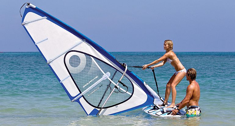
Windsurfing is a lot like riding a bicycle or skiing. They’re all easy. You just need a little nerve, and one or three fundamental tips (there’s only one for skiing, for example). If you follow the tips, and keep trying, your body will “catch on” quickly. It helps if you know how to sail a boat, but a few tips will help get you going. If you don’t use them, you may never catch on. I’ll presume that you already have your Windsurfer/sailboard assembled and floating in the water.

The essential tips are:

1. Crawl up on the board from the side away from the mast and sail. Stand up near the middle of the board, placing both feet about a foot apart and right on the centerline of the board. Maintain your balance by using your ankles in much the same way you keep your balance on dry land. Practice that a little.
Windsurfing-Lessons-in-Cagliari-Sardinia2. Pick up the halyard (rope used to raise the mast), and raise the mast to vertical. Don’t worry about the sail itself. Just let it align itself with the wind.
3. Grip the boom and pull the clew (rear) of the sail into the wind a bit, and off you go. Steer the board by pivoting the mast and sail fore or aft as needed.

You don’t need to use the nautical terms to succeed. 😀

Liberty Lake

Liberty Lake is small for a Hobie Cat, but just right for a sailboard. There was a nice launch area there too. I put my board on top of the Bronco, drove to the lake, and in 30 minutes I was enjoying high-performance sailing. Barb had a young friend at the lake too. Sometimes I used their lawn to land on, and carried my Windsurfer up the street.

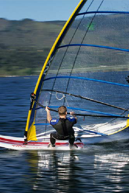
The difference in experience between conventional sailboats and sailboards is similar to the difference between powered airplanes and gliders.  You feel the wind is directly, you have a direct connection with the water, and you are immersed in the task. It’s a lot like skating, skiing or bicycling, with the added elements of wind and water.

Hawaii 

The owner of our Windsurfer shop and his friend invited me to join them for a sailboarding week in Hawaii. Doesn’t everyone need to do that once in their lives? Marcia and I joined them and their wives, and we flew to Honolulu in a 747. We had a hotel on the beach, and we, the sailors, drove over to Lanikai Beach on the east side of the island to rent sailboards each day.

There is a big shallow bay at Lanikai and Kialua (15 feet). The swells were small and widely spaced, and the water was crystal clear. The most noticeable thing was the sea turtles there. Our first day was a disaster. The sailboards recommended by the shop were practically un-sail-able in light winds. They had an odd (narrow) shape, and we just couldn’t get going on them.

The next day we rented sailboards that were more conventional. We had no trouble at all with those. There was a first break out by a couple of little islands about a mile out that took the brunt of the swells, so we had smooth sailing in the bay. It was a little wilder out by the break.

I spotted many sea turtles lazing away. They quickly dived when they spotted me. We sailed in and out for hours. We also met a local on the beach, who took us to see what had been a beach house for a Hawaiian princess. It was mostly one big open room. I’m guessing we could have bought it for $500,000. Probably $5 million now.

Sandpoint

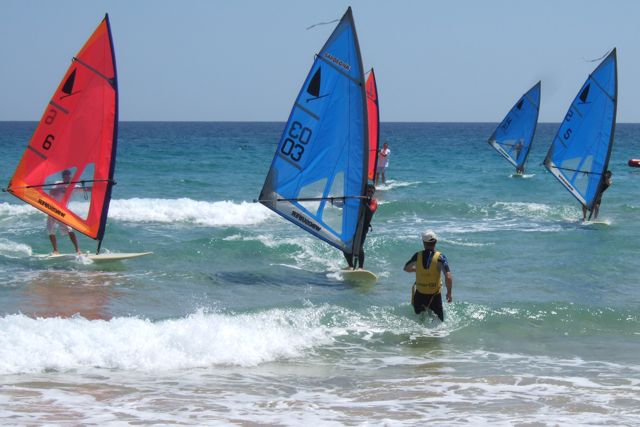
Like the Hobie Cat builders, the Windsurfer builders sponsored organized racing. There was no local racing at Spokane yet (actually never), but I did go up to Sandpoint for a Pacific NW championship regatta. There were maybe 75 Windsurfers there.

The wind was a steady 30 knots on the first day. That’s a moderate gale, and it was intimidating. I was able to handle the wind fairly well, but I could not sail to windward (upwind). The wind overpowered the sail, and I could not get the bow pointed upwind. I couldn’t even get to the starting line for the first race. But I was out on the lake (Lake Pend Oreille), and watching.

Somehow, most of the racers made the start and went skimming across the lake. The course was set on a beam reach (sailing across the wind, not into it). It was about three miles out and back, and they were moving at about 25 knots — the races lasted less than ten minutes.

hikingAs they came back, it dawned on me what they were doing. Their masts and sails were raked about 45 degrees into the wind. They had enough sail power in that wind to support most of their body weight, and they adjusted to gusts by adjusting the angle.

My approach had been too conservative. I had been trying to keep my mast close to vertical, which is what you do in moderate winds. My overpowered sail prevented me from turning upwind. Hiking way out to windward like they were doing moves the center of sail power so that the board goes upwind naturally.

That was the secret. It took a few tries, but I was soon hanging out on my sail very nicely too. It felt completely natural. Just adjust the sail power as needed using the boom. Might sound tricky, but once your body “catches on” your natural muscle instincts take over. You have a feel of smooth, solid control. I had a great time, skipping along on the top of the waves at a great rate of speed is magic.

I do not remember how I came out in the standings. Even though we got to “throw out” one bad race in a series, I probably finished somewhere in the middle of the pack. But I gained some valuable experience, which I also put to use while bicycle touring. [link: read the third paragraph]

kitesurfing
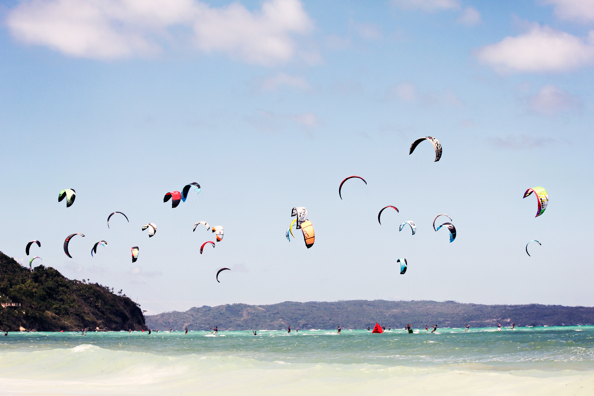
This is probably my last last post on sailing, unless I take up kitesurfing.

After that Sandpoint adventure, bicycle touring nudged board surfing aside for. The travel, coupled with the challenge and satisfaction of being in top condition had me hooked.

Hobie Cat Racing — Four

Woodward Reservoir

woodward
View Larger and Better Map

Except for one little irritation, which I’ll mention below, Woodward was a great place for racing Hobie Cats. Woodward Reservoir is located just north of Oakdale, which is near the Sierra. [*] Due to unique topography, it appears to be at the top of a large, rounded hill. Strange but true.

Woodward always attracted a large turnout of boats. Winds were usually steady there, and it was contiguous with Stanislaw County Park. We could camp and cook on grass right where our Hobies were beached, and everyone was together.

Most racers had big vans or motor homes. They felt sorry for us because we just had a tent. I forgot the tent poles one time, and they really felt sorry for us then. We draped the tent over the boom and didn’t fare too badly though — thank you very much.

The race committee was what irritated me. There almost always was a morning breeze at Woodward. It started around 9:00 am. The races started at 11:00 am, and usually died down before noon. I pleaded to have them to start at 9:00, but it is no good to argue statistics with people who disparage data.

* According to Ansel Adams, “The name Sierra is already a plural. To add a ‘s’ on the end is a linguistic, Californian, and mountaineering sin.”

Half Moon Bay

One year we had a regatta at Half Moon Bay, right where the world-renowned Mavericks surfing competition is held. There were lots of boats there, almost too many. We put in at a little harbor that relied on a big breakwater to keep the waves out.

Of course, we weren’t there when the waves were at 30 feet or more like they are Mavericks competitions. I think they were around eight feet that day, but they not breaking. Nevertheless, we could see big rocks in the troughs. Closer to shore, on the way in and out of the race course, you needed to be very careful to steer clear of those rocks in the shallower water. It was an exciting weekend of racing. (This regatta occurred years before Mavericks was “discovered.”)

Pacific Northwest

Just getting the Hobie Cat to Spokane was an adventure. Marcia, Barb and I were moving to Washington in January of 1980. I was towing the Hobie Cat with our venerable 66 Ford, and Barb was driving the Dart. She had a learning driver permit from California DOT, which probably wasn’t valid in Oregon or Washington, but we didn’t think of that. She also had the measles.

We stopped at Roseburg, Oregon for the night, and then started off early the next morning. After about 100 miles on I-5 we came over a little rise. There we saw a long string of big trucks parked on the shoulder. I soon figured out that they were all putting on chains.

We had planned to go through Columbia Gorge and on up to Spokane. We learned though that a huge arctic blast had coated the roads at lower elevations around Portland and through the gorge with black ice. We had tire chains, fortunately, so we put ours on too. We got through Portland on I-5, and it began to change from ice to snow on the road.

Soon we could go a little faster. We got to North Bend in the afternoon, where we learned that an avalanche had buried two tanker trucks on I-90. We waited in North Bend for an hour or two and decided to go over Stevens Pass instead of wait for Snoqualmie to open.

That went fine until I took a wrong, probably fortuitous turn at Wenatchee. Now we were on Highway 2, which was dark, nearly deserted, and in the middle of nowhere. We found a funky motel at Coulee City eventually. The next morning we discovered the ice storm had followed us there. I took us half a day, but we made it past all the cars and trucks in the ditches and arrived in Spokane.

First time in Idaho

Barb and I took the Hobie to Lake Coeur d’Alene on a beautiful spring day in May. We sailed out in the middle of the lake, and the wind died. Eventually, we noticed what looked like a cloud bank covered the western quadrant of the sky. I figured we were in for a terrific storm, but there we were, stranded.

Finally a little breeze came up, and we made it back to the boat launch. People were listening to the radio there, and I heard one of them say, “It’s killed six people already, and I-90 is closed.” As I hurried on to the car I felt grit on my lips. Then I realized it had to be ash from Mount Saint Helens.

The roads were already covered with ash by the time we got the Hobie on the trailer. We had never been in Coeur d’Alene before, but I saw an alternate route around Mica Peak on the map, and off we went. Fortunately, I missed the turn I wanted to take.

Now we were following a car, wondering what to do. They turned west just before we got to I-90, and I instinctively followed. We were on Appleway. It’s a backroad that was the original main road to Spokane. Thank you serendipity.

Liberty Lake

Yes, there was a Hobie Cat Fleet in Spokane, and Barb and I did some racing at Liberty Lake. Barb was the best crew member I ever had. She understood that you have to move smoothly, precisely and without delay when it’s time to maneuver in a race. We did very well for a while. But then the fleet evaporated into thin air, as they say.